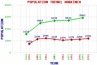
Markinch Classification and Statistics Settlement Type: village Population (2011): 2398 (2001): 2254 (1991): 2176 (1981): 2079 (1971): 2225 (1961): 2446 (1951): 2306 (1901): 1499(Police Burgh) (1881): 5863 (1871): 5413 (1861): 5375 (1831): 4967 (1801): 3130 Tourist Rating: Text of Entry Updated: 28-JUL-2009 Location Latitude: 56.2018°N Longitude: 3.133°W National Grid Reference: NO 298 016 A range of modern and historical maps are accessible through the map tab on the right of this page Get directions by entering the UK postcode of your location, home or hotel here eg. EH1 3YT Use the tabs on the right of this page to see other parts of this entry Related Entries There are 28 related entries. (3 Attractions, 1 Council Area, 1 Historical County, 1 Family, 9 Features, 1 Parish, 3 People and 9 Settlements) Names that are not linked do not currently contain any information. Attractions: Balbirnie Park Balgonie Castle Coul Den Council Area: Fife Families: Balfour Features: Balbirnie Bridge Balbirnie House Balbirnie Park Golf Course Coul Reservoir East Coast Main Line Leven Bus Station Markinch Railway Station Mount Frost Stob Cross Historical Counties: Fife Parishes: Markinch People: Saint Columba(St. Columba or Saint Colum Cille) Saint Drostan(St. Drostan) Marilyn Imrie Settlements: Cadham Coaltown of Balgonie Glenrothes Kirkcaldy Leslie Milton of Balgonie Prestonhall Star Windygates
There are 28 related entries. (3 Attractions, 1 Council Area, 1 Historical County, 1 Family, 9 Features, 1 Parish, 3 People and 9 Settlements)
Names that are not linked do not currently contain any information.
By using our site you agree to accept cookies, which help us serve you better