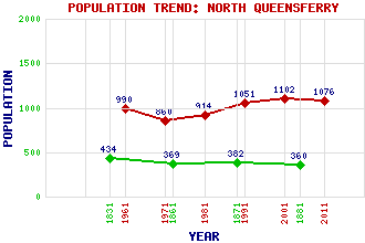
North Queensferry Classification and Statistics Settlement Type: village Population (2011): 1076 (2001): 1102 (1991): 1051 (1981): 914 (1971): 860 (1961): 990 (1881): 360 (1871): 382 (1861): 369 (1831): 434 Tourist Rating: Text of Entry Updated: 04-JUL-2023 Location Latitude: 56.0113°N Longitude: 3.3969°W National Grid Reference: NT 130 807 A range of modern and historical maps are accessible through the map tab on the right of this page Get directions by entering the UK postcode of your location, home or hotel here eg. EH1 3YT Use the tabs on the right of this page to see other parts of this entry Related Entries There are 39 related entries. (15 Attractions, 1 Council Area, 1 Historical County, 9 Features, 1 Parish, 7 People and 5 Settlements) Names that are not linked do not currently contain any information. Attractions: Briggers Memorial (North) Briggers Memorial (South) Deep Sea World Dunfermline Abbey Edinburgh Castle Ferry Hills Fife Coastal Path Forth Bridge Forth Bridge Heritage Centre Forth Road Bridge Inchgarvie Light Tower North Queensferry Railway Station Port Laing St James' Chapel Council Area: Fife Features: Beamer Rock Carlingnose Point East Bay East Coast Main Line Forth, Firth of Inverkeithing Bay North Queensferry Tunnel St Margaret's Head Tunnel St Margaret's Hope Historical Counties: Fife Parishes: Dunfermline People: Saint Andrew(St. Andrew) Iain Banks (James) Gordon Brown King David I King Malcolm IV(Malcolm the Maiden) Saint Margaret(St. Margaret; Queen Margaret) John Rennie Settlements: Dalgety Bay Inverkeithing Jamestown Rosyth South Queensferry
There are 39 related entries. (15 Attractions, 1 Council Area, 1 Historical County, 9 Features, 1 Parish, 7 People and 5 Settlements)
Names that are not linked do not currently contain any information.
By using our site you agree to accept cookies, which help us serve you better