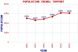
Tayport (Ferryport-on-Craig) Classification and Statistics Settlement Type: village Population (2011): 3815 (2001): 3847 (1991): 3346 (1981): 3030 (1971): 2897 (1961): 3151 Tourist Rating: No Text of Entry Updated: 21-APR-2007 Location Latitude: 56.4455°N Longitude: 2.8791°W National Grid Reference: NO 459 285 A range of modern and historical maps are accessible through the map tab on the right of this page Get directions by entering the UK postcode of your location, home or hotel here eg. EH1 3YT Use the tabs on the right of this page to see other parts of this entry Related Entries There are 29 related entries. (1 Attraction, 1 Council Area, 1 Historical County, 16 Features, 1 Parish, 4 People and 5 Settlements) Names that are not linked do not currently contain any information. Attractions: Tentsmuir Forest Council Area: Fife Features: Abertay Sands Craig Law Cupar Railway Station Leuchars Railway Station Morton Lochs North Sea Our Lady Star of the Sea Pile Lighthouse Scotscraig Golf Club Tay Bridge Tay, Firth of Tayport Parish Church Tayport West Lighthouse Tentsmuir Tentsmuir Point Tentsmuir Sands Historical Counties: Fife Parishes: Ferry Port on Craig People: Martin Anderson(Cynicus) Reginald Francis Joseph Fairlie Thomas Grainger Douglas Young Settlements: Broughty Ferry Dundee Kennoway St Andrews Washer Willy's
There are 29 related entries. (1 Attraction, 1 Council Area, 1 Historical County, 16 Features, 1 Parish, 4 People and 5 Settlements)
Names that are not linked do not currently contain any information.
By using our site you agree to accept cookies, which help us serve you better