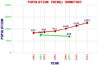
Bankfoot (Auchtergaven) Classification and Statistics Settlement Type: village Population (2011): 1257 (2001): 1136 (1991): 1009 (1981): 911 (1971): 868 (1961): 837 (1871): 689 (1861): 748 Tourist Rating: No Text of Entry Updated: 04-MAR-2012 Location Latitude: 56.4995°N Longitude: 3.5237°W National Grid Reference: NO 063 352 A range of modern and historical maps are accessible through the map tab on the right of this page Get directions by entering the UK postcode of your location, home or hotel here eg. EH1 3YT Use the tabs on the right of this page to see other parts of this entry Related Entries There are 17 related entries. (1 Attraction, 1 Council Area, 1 Historical County, 7 Features, 1 Parish, 2 People and 4 Settlements) Names that are not linked do not currently contain any information. Attractions: Scottish Liqueur Centre, The Council Area: Perth and Kinross Features: A9 Trunk Road Auchtergaven Auchtergaven Parish Church Obney Hills Ordie Burn Shee, Glen Strathord Historical Counties: Perthshire Parishes: Auchtergaven People: James Miller Robert Nicoll Settlements: Dunkeld Obney Tullybelton Waterloo
There are 17 related entries. (1 Attraction, 1 Council Area, 1 Historical County, 7 Features, 1 Parish, 2 People and 4 Settlements)
Names that are not linked do not currently contain any information.
By using our site you agree to accept cookies, which help us serve you better