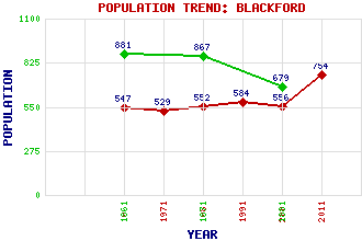
Blackford Classification and Statistics Settlement Type: village Population (2011): 754 (2001): 556 (1991): 584 (1981): 552 (1971): 529 (1961): 547 (1881): 679 (1871): 867 (1861): 881 Tourist Rating: No Text of Entry Updated: 15-JUL-2019 Location Latitude: 56.2606°N Longitude: 3.7789°W National Grid Reference: NN 899 090 A range of modern and historical maps are accessible through the map tab on the right of this page Get directions by entering the UK postcode of your location, home or hotel here eg. EH1 3YT Use the tabs on the right of this page to see other parts of this entry Related Entries There are 26 related entries. (2 Attractions, 1 Council Area, 1 Historical County, 1 Event, 13 Features, 1 Parish, 3 People and 4 Settlements) Names that are not linked do not currently contain any information. Attractions: Gleneagles Hotel Tullibardine Distillery Council Area: Perth and Kinross Events: Battle of Sheriffmuir Features: Allan Water Bee, Glen Burnfoot Hill Carim Lodge Core Hill Craigentaggert Hill Glasgow-Perth Line Kinpauch Hill Kinpauch, Glen of Scadlaw Strathallan Tambeth Wether Hill Historical Counties: Perthshire Parishes: Blackford People: Alexander Buchan William Delmé-Evans King James IV Settlements: Carsebreck Perth Stirling Tullibardine
There are 26 related entries. (2 Attractions, 1 Council Area, 1 Historical County, 1 Event, 13 Features, 1 Parish, 3 People and 4 Settlements)
Names that are not linked do not currently contain any information.
By using our site you agree to accept cookies, which help us serve you better