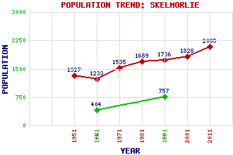
Skelmorlie Classification and Statistics Settlement Type: village Population (2011): 2095 (2001): 1828 (1991): 1736 (1981): 1689 (1971): 1535 (1961): 1233 (1951): 1327 (1881): 757 (1871): 404 Tourist Rating: N/A Text of Entry Updated: 18-JUL-2022 Location Latitude: 55.8667°N Longitude: 4.8861°W National Grid Reference: NS 195 675 A range of modern and historical maps are accessible through the map tab on the right of this page Get directions by entering the UK postcode of your location, home or hotel here eg. EH1 3YT Use the tabs on the right of this page to see other parts of this entry Related Entries There are 20 related entries. (2 Attractions, 1 Council Area, 1 Historical County, 1 Family, 10 Features, 1 Parish, 1 Person and 3 Settlements) Names that are not linked do not currently contain any information. Attractions: Ayrshire Coastal Path Skelmorlie Castle Council Area: North Ayrshire Families: Montgomery Features: Clyde, Firth of Kelly Burn Knock Old Castle Knockencorsan Outerwards Reservoir Peat Hill Skelmorlie Golf Club Toward Point Wemyss Bay White Hill Historical Counties: Ayrshire Parishes: Largs People: Rev. Dr. Donald Caskie Settlements: Largs Upper Skelmorlie Wemyss Bay
There are 20 related entries. (2 Attractions, 1 Council Area, 1 Historical County, 1 Family, 10 Features, 1 Parish, 1 Person and 3 Settlements)
Names that are not linked do not currently contain any information.
By using our site you agree to accept cookies, which help us serve you better