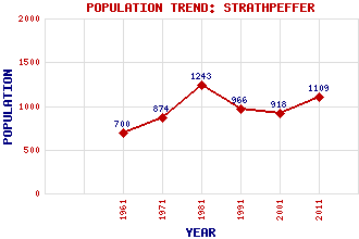
Strathpeffer Classification and Statistics Settlement Type: village Population (2011): 1109 (2001): 918 (1991): 966 (1981): 1243 (1971): 874 (1961): 700 Tourist Rating: Yes Text of Entry Updated: 13-FEB-2021 Location Latitude: 57.5892°N Longitude: 4.5377°W National Grid Reference: NH 484 583 A range of modern and historical maps are accessible through the map tab on the right of this page Get directions by entering the UK postcode of your location, home or hotel here eg. EH1 3YT References and Further Reading Finlayson, Clarence (1979) The Strath: The Biography of Strathpeffer. The Saint Andrew Press, Edinburgh Use the tabs on the right of this page to see other parts of this entry Related Entries There are 33 related entries. (2 Attractions, 1 Council Area, 1 Historical County, 19 Features, 1 Parish, 3 People and 6 Settlements) Names that are not linked do not currently contain any information. Attractions: Highland Museum of Childhood Strathpeffer Spa Pavilion Council Area: Highland Features: Achilty, Loch Achonachie, Loch Ben Wyvis Black Water Castle Leod Crann, Loch na Garve Railway Station Garve, Loch Glascarnoch, Loch Kinellan, Loch Knockfarrel Kyle of Lochalsh Line Loch Kinellan Crannog Luichart, Loch Peffer, Strath Rogie Burn Rogie, Falls of Strathpeffer Spa Golf Club Ussie, Loch Historical Counties: Ross and Cromarty Parishes: Fodderty People: Julie Fowlis William (Willie) Logan Robert Louis Stevenson(Robert Lewis Balfour Stevenson) Settlements: Auchterneed Contin Dingwall Fodderty Jamestown Marybank
There are 33 related entries. (2 Attractions, 1 Council Area, 1 Historical County, 19 Features, 1 Parish, 3 People and 6 Settlements)
Names that are not linked do not currently contain any information.
By using our site you agree to accept cookies, which help us serve you better