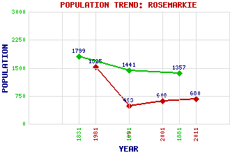
Rosemarkie Classification and Statistics Settlement Type: village Population (2011): 680 (2001): 608 (1991): 493 (1981): 1525 (1881): 1357 (1871): 1441 (1831): 1799 Tourist Rating: Text of Entry Updated: 28-FEB-2004 Location Latitude: 57.5906°N Longitude: 4.1161°W National Grid Reference: NH 736 576 A range of modern and historical maps are accessible through the map tab on the right of this page Get directions by entering the UK postcode of your location, home or hotel here eg. EH1 3YT Use the tabs on the right of this page to see other parts of this entry Related Entries There are 14 related entries. (3 Attractions, 1 Council Area, 1 Historical County, 5 Features, 1 Parish, 2 People and 1 Settlement) Names that are not linked do not currently contain any information. Attractions: Fort George Groam House Museum Rosemarkie Bay Council Area: Highland Features: Black Isle Black Isle Education Centre Easter Ross Moray Firth Rosemarkie Transmitting Station Historical Counties: Ross and Cromarty Parishes: Rosemarkie People: George Bain Saint Boniface Curitan(St Boniface Curitan; Bishop of Ross) Settlements: Fortrose
There are 14 related entries. (3 Attractions, 1 Council Area, 1 Historical County, 5 Features, 1 Parish, 2 People and 1 Settlement)
Names that are not linked do not currently contain any information.
By using our site you agree to accept cookies, which help us serve you better