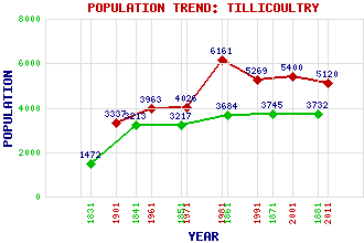
Tillicoultry Classification and Statistics Settlement Type: small town Population (2011): 5120 (2001): 5400 (1991): 5269 (1981): 6161(Combined with Coalsnaughton and Devonside) (1971): 4026 (1961): 3963 (1901): 3337(Police Burgh) (1881): 3732 (1871): 3745 (1861): 3684 (1851): 3217 (1841): 3213 (1831): 1472 Tourist Rating: Text of Entry Updated: 25-JUL-2019 Location Latitude: 56.1525°N Longitude: 3.7401°W National Grid Reference: NS 920 969 A range of modern and historical maps are accessible through the map tab on the right of this page Get directions by entering the UK postcode of your location, home or hotel here eg. EH1 3YT Use the tabs on the right of this page to see other parts of this entry Related Entries There are 37 related entries. (4 Attractions, 1 Council Area, 1 Historical County, 17 Features, 1 Parish, 6 People and 7 Settlements) Names that are not linked do not currently contain any information. Attractions: Firpark Ski Centre Mill Glen Ochil Hills Woodland Park Scotland's Mill Trail Visitor Centre Council Area: Clackmannanshire Features: Andrew Gannel Hill Ben Cleuch Daiglen Burn Devon, River Elistoun Hill Gannel Burn Harviestoun Hillfoots, The King's Seat Hill Kirk Craigs Law, The Middle Hill Ochil Hills Tillicoultry Burn Tillicoultry Golf Club Upper Glendevon Reservoir Wood Hill Historical Counties: Clackmannanshire Parishes: Tillicoultry People: Helen Denerley Alastair Hetherington (William) George Pottinger William Stirling (Robert) Douglas Strachan Sir Charles Tennant Settlements: Alva Coalsnaughton Devon Village Dollar Galashiels Kilbagie Sauchie
There are 37 related entries. (4 Attractions, 1 Council Area, 1 Historical County, 17 Features, 1 Parish, 6 People and 7 Settlements)
Names that are not linked do not currently contain any information.
By using our site you agree to accept cookies, which help us serve you better