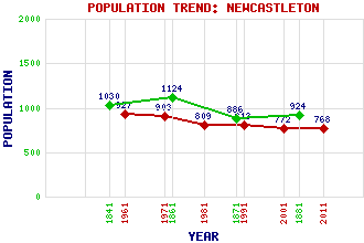
Newcastleton (Copshaw Holm) Classification and Statistics Settlement Type: village Population (2011): 768 (2001): 772 (1991): 813 (1981): 809 (1971): 903 (1961): 927 (1881): 924 (1871): 886 (1861): 1124 (1841): 1030 Tourist Rating: Text of Entry Updated: 04-JUN-2006 Location Latitude: 55.179°N Longitude: 2.8133°W National Grid Reference: NY 483 875 A range of modern and historical maps are accessible through the map tab on the right of this page Get directions by entering the UK postcode of your location, home or hotel here eg. EH1 3YT Use the tabs on the right of this page to see other parts of this entry Related Entries There are 43 related entries. (2 Attractions, 1 Council Area, 1 Historical County, 1 Family, 26 Features, 1 Parish, 3 People and 8 Settlements) Names that are not linked do not currently contain any information. Attractions: Hermitage Castle Hermitage Chapel Council Area: Scottish Borders Families: Buccleuch Features: Black Burn Black Edge Black Knowe Blinkbonny Height Branxholme Castle Cockplay Hill Din Fell Ewe Hill Geordie's Hill Greena Hill Hartsgarth Fell Kershope Burn Kirk Hill Liddel Water Liddesdale Loch Knowe Millingwood Fell Newcastleton Golf Club North Birny Fell Roan Fell Saughtree Fell Scawd Bank Tinnis Hill Watch Hill Wetherhorn Hill Wilson's Pike Historical Counties: Roxburghshire Parishes: Castleton People: Dr. Richard Henderson Richard Henderson Eric Robson Settlements: Hawick Langholm Newlands Riccarton Riccarton Junction Sandholm Saughtree Twislehope
There are 43 related entries. (2 Attractions, 1 Council Area, 1 Historical County, 1 Family, 26 Features, 1 Parish, 3 People and 8 Settlements)
Names that are not linked do not currently contain any information.
By using our site you agree to accept cookies, which help us serve you better