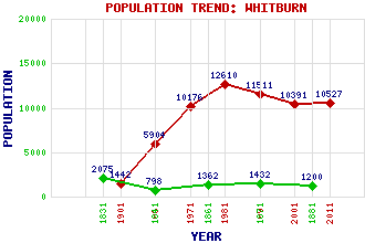
Whitburn Classification and Statistics Settlement Type: small town Population (2011): 10527 (2001): 10391 (1991): 11511 (1981): 12610(Combined with Eastburn) (1971): 10176 (1961): 5904 (1901): 1442(Police Burgh) (1881): 1200 (1871): 1432 (1861): 1362 (1841): 798 (1831): 2075 Tourist Rating: No Text of Entry Updated: 06-MAR-2020 Location Latitude: 55.8666°N Longitude: 3.6857°W National Grid Reference: NS 946 650 A range of modern and historical maps are accessible through the map tab on the right of this page Get directions by entering the UK postcode of your location, home or hotel here eg. EH1 3YT Use the tabs on the right of this page to see other parts of this entry Related Entries There are 31 related entries. (3 Attractions, 1 Council Area, 1 Historical County, 1 Family, 8 Features, 1 Parish, 5 People and 11 Settlements) Names that are not linked do not currently contain any information. Attractions: Horn, The Polkemmet Country Park Scottish Vintage Bus Museum Council Area: West Lothian Families: Baillie Features: Almond Valley Almond, River Burnhouse School King George V Park Polkemmet Golf Club Polkemmet Moor Torbane Hill Whitburn Academy Historical Counties: West Lothian Parishes: Whitburn People: John Brown Robert Burns Lewis Capaldi Sir Adam Forrester Andrew (Andy) Mooney Settlements: Armadale Bathgate Bathville Bents Blackburn East Whitburn Harthill Livingston Longridge Tippethill Torbanehill
There are 31 related entries. (3 Attractions, 1 Council Area, 1 Historical County, 1 Family, 8 Features, 1 Parish, 5 People and 11 Settlements)
Names that are not linked do not currently contain any information.
By using our site you agree to accept cookies, which help us serve you better