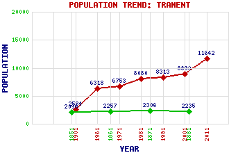
Tranent Classification and Statistics Settlement Type: small town Population (2011): 11642 (2001): 8892 (1991): 8313 (1981): 8080 (1971): 6753 (1961): 6318 (1901): 2584(Police Burgh) (1881): 2235 (1871): 2306 (1861): 2257 (1851): 2096 Tourist Rating: Text of Entry Updated: 14-JUL-2019 Location Latitude: 55.9445°N Longitude: 2.9542°W National Grid Reference: NT 405 728 A range of modern and historical maps are accessible through the map tab on the right of this page Get directions by entering the UK postcode of your location, home or hotel here eg. EH1 3YT References and Further Reading M'Neill, P. (1883) Tranent and its Surroundings. John Menzies and Co, Edinburgh and Glasgow Use the tabs on the right of this page to see other parts of this entry Related Entries There are 37 related entries. (2 Attractions, 1 Council Area, 1 Historical County, 1 Event, 8 Features, 1 Parish, 6 People and 17 Settlements) Names that are not linked do not currently contain any information. Attractions: Prestonpans Battlefield Tranent Parish Church Council Area: East Lothian Events: Reformation, The Features: A1 Trunk Road Birns Water Elphinstone Research Centre Elphinstone Tower Fa'side Castle Prestonpans Railway Station Ross High School St Joseph's School Historical Counties: East Lothian Parishes: Tranent People: Euan Burton Joan (Jackie) Crookston Colonel James Gardiner Alexander (Alex) Marshall(Tattie Marshall) Andrew (Drew) Emyln McMaster John Robertson Settlements: Blindwells Cockenzie Cockenzie and Port Seton Dolphingstone Elphinstone Gladsmuir Haddington Keith Longniddry Macmerry Musselburgh New Town New Winton Newbattle Ormiston Port Seton Prestonpans
There are 37 related entries. (2 Attractions, 1 Council Area, 1 Historical County, 1 Event, 8 Features, 1 Parish, 6 People and 17 Settlements)
Names that are not linked do not currently contain any information.
By using our site you agree to accept cookies, which help us serve you better