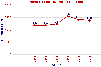
Hurlford Classification and Statistics Settlement Type: village Population (2011): 4846 (Combined with Crookedholm) (2001): 4968 (1991): 5419 (1971): 4294 (1961): 4152 (1951): 4147 Tourist Rating: No Text of Entry Updated: 23-JUL-2019 Location Latitude: 55.5984°N Longitude: 4.4536°W National Grid Reference: NS 455 366 A range of modern and historical maps are accessible through the map tab on the right of this page Get directions by entering the UK postcode of your location, home or hotel here eg. EH1 3YT Use the tabs on the right of this page to see other parts of this entry Related Entries There are 12 related entries. (0 Attractions, 1 Council Area, 1 Historical County, 1 Family, 3 Features, 1 Parish, 1 Person and 4 Settlements) Names that are not linked do not currently contain any information. Council Area: East Ayrshire Families: Wallace Features: Cessnock Water Irvine, River Mossgiel Tunnel Historical Counties: Ayrshire Parishes: Riccarton People: William Wallace Settlements: Crookedholm Crossroads Galston Kilmarnock
There are 12 related entries. (0 Attractions, 1 Council Area, 1 Historical County, 1 Family, 3 Features, 1 Parish, 1 Person and 4 Settlements)
Names that are not linked do not currently contain any information.
By using our site you agree to accept cookies, which help us serve you better