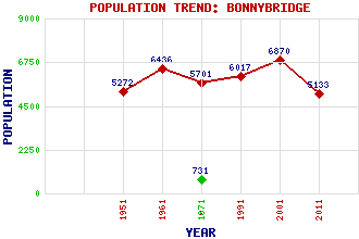
Bonnybridge Classification and Statistics Settlement Type: small town Population (2011): 5133 (2001): 6870 (1991): 6017 (1971): 5701 (1961): 6436 (1951): 5272 (1871): 731 Tourist Rating: No Text of Entry Updated: 25-JUN-2018 Location Latitude: 56.0031°N Longitude: 3.8793°W National Grid Reference: NS 829 805 A range of modern and historical maps are accessible through the map tab on the right of this page Get directions by entering the UK postcode of your location, home or hotel here eg. EH1 3YT Use the tabs on the right of this page to see other parts of this entry Related Entries There are 30 related entries. (6 Attractions, 1 Council Area, 1 Historical County, 10 Features, 1 Parish, 3 People and 8 Settlements) Names that are not linked do not currently contain any information. Attractions: Antonine Wall, The Falkirk Wheel Forth and Clyde Canal John Muir Way Rough Castle Fort Roughcastle Community Woodland Council Area: Falkirk Features: Bonny Water Bonnybridge Golf Club Cumbernauld Airport Cumbernauld Line Edinburgh Airport Glasgow Airport Glasgow-Perth Line Larbert Junction Little Denny Reservoir Milnquarter Historical Counties: Stirlingshire Parishes: Falkirk People: Thomas (Tom) Duncan Reginald Francis Joseph Fairlie Paul Grime Settlements: Allandale Camelon Denny Dennyloanhead Dunipace Falkirk Greenhill High Bonnybridge
There are 30 related entries. (6 Attractions, 1 Council Area, 1 Historical County, 10 Features, 1 Parish, 3 People and 8 Settlements)
Names that are not linked do not currently contain any information.
By using our site you agree to accept cookies, which help us serve you better