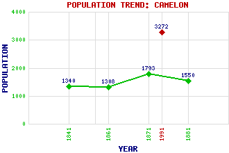
Camelon Classification and Statistics Settlement Type: settlement Population (1991): 3272 (1881): 1550 (1871): 1793 (1861): 1308 (1841): 1340 Tourist Rating: No Text of Entry Updated: 27-JUL-2020 Location Latitude: 56.0021°N Longitude: 3.8231°W National Grid Reference: NS 864 803 A range of modern and historical maps are accessible through the map tab on the right of this page Get directions by entering the UK postcode of your location, home or hotel here eg. EH1 3YT Use the tabs on the right of this page to see other parts of this entry Related Entries There are 27 related entries. (7 Attractions, 1 Council Area, 1 Historical County, 7 Features, 1 Parish, 2 People and 8 Settlements) Names that are not linked do not currently contain any information. Attractions: Antonine Wall, The Callendar House Dorrator Iron Bridge Falkirk Wheel Forth and Clyde Canal Mariner Centre Union Canal Council Area: Falkirk Features: Camelon Railway Station Falkirk Crematorium Falkirk Golf Club Carmuirs Falkirk High Railway Station Falkirk Sheriff Court Gask Ridge Larbert Junction Historical Counties: Stirlingshire Parishes: Falkirk People: Andrew Greig Barr Dame Sheila Marshall McKechnie Settlements: Bonnybridge Falkirk Grangemouth Greenhill Larbert Shieldhill Slamannan Torwood
There are 27 related entries. (7 Attractions, 1 Council Area, 1 Historical County, 7 Features, 1 Parish, 2 People and 8 Settlements)
Names that are not linked do not currently contain any information.
By using our site you agree to accept cookies, which help us serve you better