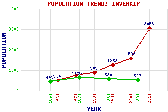
Inverkip Classification and Statistics Settlement Type: village Population (2011): 3058 (2001): 1598 (1991): 1258 (1981): 905 (1971): 751 (1961): 504 (1891): 526 (1881): 580 (1871): 637 (1861): 449 Tourist Rating: Text of Entry Updated: 09-JAN-2007 Location Latitude: 55.9075°N Longitude: 4.8715°W National Grid Reference: NS 206 720 A range of modern and historical maps are accessible through the map tab on the right of this page Get directions by entering the UK postcode of your location, home or hotel here eg. EH1 3YT Use the tabs on the right of this page to see other parts of this entry Related Entries There are 29 related entries. (3 Attractions, 1 Council Area, 1 Historical County, 1 Event, 18 Features, 1 Parish, 2 People and 2 Settlements) Names that are not linked do not currently contain any information. Attractions: Clyde Muirshiel Regional Park Paisley Abbey Shieldhill Glen Council Area: Inverclyde Events: Reformation, The Features: Ardgowan House Ardgowan Point Ardgowan Tower Bargane Hill Brown Hill Clyde, Firth of Compensation Loch Daff Reservoir Dunrod Hill Inverkip Bay Inverkip Power Station Inverkip Railway Station Kelly Cut Kip Marina Kip Water Lunderston Bay Spango Valley Wenchly Top Historical Counties: Renfrewshire Parishes: Inverkip People: Derek Holt James Young(James 'Paraffin' Young) Settlements: Dunrod Greenock
There are 29 related entries. (3 Attractions, 1 Council Area, 1 Historical County, 1 Event, 18 Features, 1 Parish, 2 People and 2 Settlements)
Names that are not linked do not currently contain any information.
By using our site you agree to accept cookies, which help us serve you better