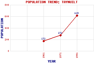
Taynuilt Classification and Statistics Settlement Type: village Population (1991): 615 (1971): 272 (1961): 172 Tourist Rating: N/A Text of Entry Updated: 02-OCT-2005 Location Latitude: 56.4297°N Longitude: 5.2385°W National Grid Reference: NN 004 311 A range of modern and historical maps are accessible through the map tab on the right of this page Get directions by entering the UK postcode of your location, home or hotel here eg. EH1 3YT Use the tabs on the right of this page to see other parts of this entry Related Entries There are 32 related entries. (4 Attractions, 1 Council Area, 1 Historical County, 13 Features, 1 Parish, 4 People and 8 Settlements) Names that are not linked do not currently contain any information. Attractions: Bonawe Iron Furnace Cruachan Power Station Nelson's Monument Oban Branch Council Area: Argyll and Bute Features: Airds Bay Airds Point Beinn Ghlas Wind Farm Beinn Molurgainn Beinn a' Chochuill Cruach Airdeny Duirinnis, Eilean Inverawe Power Station Lorn, Firth of Nant, Glen Nant, River Taynuilt Golf Club Taynuilt Railway Station Historical Counties: Argyllshire Parishes: Ardchattan and Muckairn People: Iain Crichton Smith(Iain MacGhobhainn) Kenneth (Kenny) MacIntyre Kenneth MacLeod Saint Modan(St. Modan) Settlements: Achlonan Bonawe Bonawe Quarries Brochroy Cadderlie Connel Dail Kilchrenan
There are 32 related entries. (4 Attractions, 1 Council Area, 1 Historical County, 13 Features, 1 Parish, 4 People and 8 Settlements)
Names that are not linked do not currently contain any information.
By using our site you agree to accept cookies, which help us serve you better