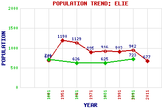
Elie Classification and Statistics Settlement Type: village Population (2011): 677 (Combined with Earlsferry) (2001): 942 (1991): 903 (1981): 916 (1971): 895 (1961): 1129 (1951): 1190 (1901): 687(Police Burgh) (1891): 723 (1881): 625 (1871): 626 (1861): 706 Tourist Rating: Text of Entry Updated: 03-AUG-2017 Location Latitude: 56.1908°N Longitude: 2.8201°W National Grid Reference: NO 492 001 A range of modern and historical maps are accessible through the map tab on the right of this page Get directions by entering the UK postcode of your location, home or hotel here eg. EH1 3YT References and Further Reading McCallien, W.J. (1937) Scottish Gemstones. Blackie & Son Limited, Glasgow Use the tabs on the right of this page to see other parts of this entry Related Entries There are 23 related entries. (3 Attractions, 1 Council Area, 1 Historical County, 1 Family, 6 Features, 1 Parish, 5 People and 5 Settlements) Names that are not linked do not currently contain any information. Attractions: Ardross Castle Fife Coastal Path Lady's Tower Council Area: Fife Families: Anstruther Features: East Vows Elie Golf Course Elie Golf Course Elie House Elie Ness Lighthouse Kilconquhar Loch Historical Counties: Fife Parishes: Elie People: William Baird James Braid King James VI(James I of England) Richard Sanderson Keen(Lord Keen of Elie) Rev. Robert Traill Settlements: Colinsburgh Drumeldrie Earlsferry Kilconquhar St Monans
There are 23 related entries. (3 Attractions, 1 Council Area, 1 Historical County, 1 Family, 6 Features, 1 Parish, 5 People and 5 Settlements)
Names that are not linked do not currently contain any information.
By using our site you agree to accept cookies, which help us serve you better