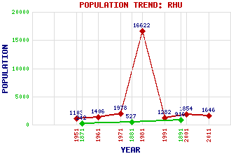
Rhu (Row) Classification and Statistics Settlement Type: village Population (2011): 1646 (2001): 1854(Combined with Shandon) (1991): 1282(Combined with Shandon) (1981): 16622(Combined with Helensburgh) (1971): 1978(Combined with Shandon) (1961): 1406(Combined with Shandon) (1951): 1103 (1891): 916 (1881): 527 (1871): 242 Tourist Rating: N/A Text of Entry Updated: 12-APR-2021 Location Latitude: 56.0174°N Longitude: 4.7834°W National Grid Reference: NS 266 840 A range of modern and historical maps are accessible through the map tab on the right of this page Get directions by entering the UK postcode of your location, home or hotel here eg. EH1 3YT Use the tabs on the right of this page to see other parts of this entry Related Entries There are 13 related entries. (1 Attraction, 1 Council Area, 1 Historical County, 4 Features, 1 Parish, 2 People and 3 Settlements) Names that are not linked do not currently contain any information. Attractions: West Highland Line Council Area: Argyll and Bute Features: Gare Loch Highlandman's Road St Andrew's School Tom na h-Airidh Historical Counties: Dunbartonshire Parishes: Rhu People: Henry Bell James Smith Settlements: Helensburgh Rosneath Shandon
There are 13 related entries. (1 Attraction, 1 Council Area, 1 Historical County, 4 Features, 1 Parish, 2 People and 3 Settlements)
Names that are not linked do not currently contain any information.
By using our site you agree to accept cookies, which help us serve you better