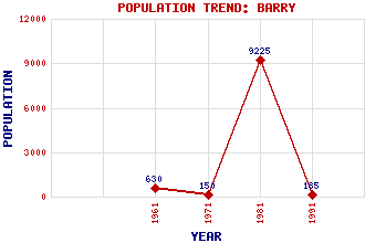
Barry Classification and Statistics Settlement Type: village Population (1991): 185 (1981): 9225(Combined with Carnoustie) (1971): 150 (1961): 630 Tourist Rating: Text of Entry Updated: 05-FEB-2007 Location Latitude: 56.4984°N Longitude: 2.7585°W National Grid Reference: NO 534 343 A range of modern and historical maps are accessible through the map tab on the right of this page Get directions by entering the UK postcode of your location, home or hotel here eg. EH1 3YT Use the tabs on the right of this page to see other parts of this entry Related Entries There are 13 related entries. (2 Attractions, 1 Council Area, 1 Historical County, 6 Features, 1 Parish, 1 Person and 1 Settlement) Names that are not linked do not currently contain any information. Attractions: Barry Links Barry Mill Council Area: Angus Features: Barry Buddon Training Centre Barry Links Railway Station Camus's Cross East Coast Main Line Panmure Golf Course Pitairlie Burn Historical Counties: Angus Parishes: Barry People: Dr. Sir John Kirk Settlements: Carnoustie
There are 13 related entries. (2 Attractions, 1 Council Area, 1 Historical County, 6 Features, 1 Parish, 1 Person and 1 Settlement)
Names that are not linked do not currently contain any information.
By using our site you agree to accept cookies, which help us serve you better