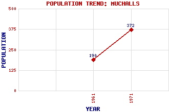
Muchalls Classification and Statistics Settlement Type: village Population (1971): 372 (1961): 190 Tourist Rating: N/A Text of Entry Updated: 06-SEP-2007 Location Latitude: 57.0208°N Longitude: 2.1613°W National Grid Reference: NO 903 922 A range of modern and historical maps are accessible through the map tab on the right of this page Get directions by entering the UK postcode of your location, home or hotel here eg. EH1 3YT Use the tabs on the right of this page to see other parts of this entry Related Entries There are 13 related entries. (0 Attractions, 1 Council Area, 1 Historical County, 2 Families, 4 Features, 1 Parish, 2 People and 2 Settlements) Names that are not linked do not currently contain any information. Council Area: Aberdeenshire Families: Burnett Fraser Features: Doonie Point Grim Brigs Hall Bay May Craig Historical Counties: Kincardineshire Parishes: Fetteresso People: Richard Henry Brunton Saint Ternan(St. Ternan) Settlements: Cookney Stonehaven
There are 13 related entries. (0 Attractions, 1 Council Area, 1 Historical County, 2 Families, 4 Features, 1 Parish, 2 People and 2 Settlements)
Names that are not linked do not currently contain any information.
By using our site you agree to accept cookies, which help us serve you better