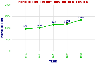
Anstruther Easter Classification and Statistics Settlement Type: village Population (1901): 1187 (Parliamentary Burgh) (1881): 1349 (1871): 1169 (1851): 1146 (1831): 1007 (1801): 969 Tourist Rating: No Text of Entry Updated: 06-FEB-2007 Location Latitude: 56.2221°N Longitude: 2.6966°W National Grid Reference: NO 569 035 A range of modern and historical maps are accessible through the map tab on the right of this page Get directions by entering the UK postcode of your location, home or hotel here eg. EH1 3YT Use the tabs on the right of this page to see other parts of this entry Related Entries There are 12 related entries. (0 Attractions, 1 Council Area, 1 Historical County, 2 Features, 1 Parish, 3 People and 4 Settlements) Names that are not linked do not currently contain any information. Council Area: Fife Features: Anstruther Bay Dreel Burn Historical Counties: Fife Parishes: Anstruther Easter People: Dr. Thomas Chalmers Henry (Harry) Duncan Spens Goodsir Robert Anstruther Goodsir Settlements: Anstruther Anstruther Wester Cellardyke Crail
There are 12 related entries. (0 Attractions, 1 Council Area, 1 Historical County, 2 Features, 1 Parish, 3 People and 4 Settlements)
Names that are not linked do not currently contain any information.
By using our site you agree to accept cookies, which help us serve you better