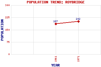
Roybridge (Roy Bridge) Classification and Statistics Settlement Type: village Population (1971): 202 (1961): 187 Tourist Rating: N/A Text of Entry Updated: 24-JUL-2015 Location Latitude: 56.8913°N Longitude: 4.8417°W National Grid Reference: NN 269 813 A range of modern and historical maps are accessible through the map tab on the right of this page Get directions by entering the UK postcode of your location, home or hotel here eg. EH1 3YT Use the tabs on the right of this page to see other parts of this entry Related Entries There are 24 related entries. (2 Attractions, 1 Council Area, 1 Historical County, 13 Features, 1 Parish, 2 People and 4 Settlements) Names that are not linked do not currently contain any information. Attractions: Roy, Glen West Highland Line Council Area: Highland Features: Beinn Chlianaig Corrour Lodge Keppoch Laire, Allt Leana Mhor Leana Mhor Lochaber Moy, Loch Roy Bridge Railway Station Roy, River Spean, Glen Spean, River Turret, River Historical Counties: Inverness-shire Parishes: Kilmonivaig People: Reginald Francis Joseph Fairlie John Rhind Settlements: Achluachrach Bohenie Bohuntine Spean Bridge
There are 24 related entries. (2 Attractions, 1 Council Area, 1 Historical County, 13 Features, 1 Parish, 2 People and 4 Settlements)
Names that are not linked do not currently contain any information.
By using our site you agree to accept cookies, which help us serve you better