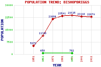
Bishopbriggs Classification and Statistics Settlement Type: town Population (2011): 22870 (2001): 23118 (1991): 23825 (1981): 23501 (1971): 21684 (1961): 11388 (1951): 5272 (1871): 782 (1861): 658 Tourist Rating: No Text of Entry Updated: 28-JUL-2009 Location Latitude: 55.9038°N Longitude: 4.2249°W National Grid Reference: NS 610 701 A range of modern and historical maps are accessible through the map tab on the right of this page Get directions by entering the UK postcode of your location, home or hotel here eg. EH1 3YT Use the tabs on the right of this page to see other parts of this entry Related Entries There are 29 related entries. (2 Attractions, 1 Council Area, 1 Historical County, 13 Features, 1 Parish, 7 People and 4 Settlements) Names that are not linked do not currently contain any information. Attractions: Bearyards Water Tower Forth and Clyde Canal Council Area: East Dunbartonshire Features: Ashfield Railway Station Bishopbriggs Academy Bishopbriggs Golf Club, The Bishopbriggs Railway Station Colston Glasgow Queen Street Railway Station HM Prison Low Moss High Possil Mavis Valley Milton Possil Loch Stobhill Hospital Turnbull High School Historical Counties: Lanarkshire Parishes: Cadder People: Peter Capaldi Amy Macdonald Sadie McLellan Thomas Muir Sir William Stirling Maxwell Sir Archibald Stirling of Keir(Lord Garden) Duncan (Dunky) Walker Settlements: Auchinairn Cadder Glasgow Lenzie
There are 29 related entries. (2 Attractions, 1 Council Area, 1 Historical County, 13 Features, 1 Parish, 7 People and 4 Settlements)
Names that are not linked do not currently contain any information.
By using our site you agree to accept cookies, which help us serve you better