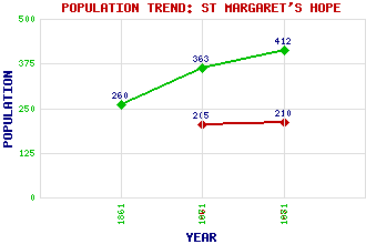
St Margaret's Hope Classification and Statistics Settlement Type: village Population (1971): 210 (1961): 205 (1881): 412 (1871): 363 (1861): 260 Tourist Rating: No Text of Entry Updated: 18-FEB-2007 Location Latitude: 58.8254°N Longitude: 2.9611°W National Grid Reference: ND 446 935 A range of modern and historical maps are accessible through the map tab on the right of this page Get directions by entering the UK postcode of your location, home or hotel here eg. EH1 3YT Use the tabs on the right of this page to see other parts of this entry Related Entries There are 16 related entries. (1 Attraction, 1 Council Area, 1 Historical County, 7 Features, 1 Parish, 0 People and 5 Settlements) Names that are not linked do not currently contain any information. Attractions: Orkney Wireless Museum Council Area: Orkney Features: Hoxa Head Hoxa Head Lighthouse Manse Bay South Ronaldsay South Ronaldsay Golf Club Ward Hill Wart, The Historical Counties: Orkney Parishes: South Ronaldsay Settlements: Cleat Gills Hoxa Quindry Sandwick
There are 16 related entries. (1 Attraction, 1 Council Area, 1 Historical County, 7 Features, 1 Parish, 0 People and 5 Settlements)
Names that are not linked do not currently contain any information.
By using our site you agree to accept cookies, which help us serve you better