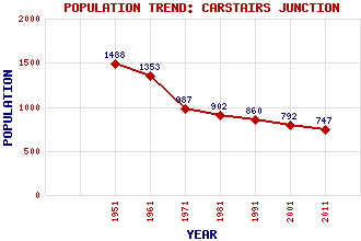
Carstairs Junction Classification and Statistics Settlement Type: village Population (2011): 747 (2001): 792 (1991): 860 (1981): 902 (1971): 987 (1961): 1353 (1951): 1488 Tourist Rating: N/A Text of Entry Updated: 21-DEC-2020 Location Latitude: 55.6886°N Longitude: 3.6645°W National Grid Reference: NS 954 451 A range of modern and historical maps are accessible through the map tab on the right of this page Get directions by entering the UK postcode of your location, home or hotel here eg. EH1 3YT Use the tabs on the right of this page to see other parts of this entry Related Entries There are 21 related entries. (0 Attractions, 1 Council Area, 1 Historical County, 10 Features, 1 Parish, 0 People and 8 Settlements) Names that are not linked do not currently contain any information. Council Area: South Lanarkshire Features: Carstairs Kames Clyde, River Clydesdale Float Moss Glasgow Central Railway Station Lockerbie Railway Station Meetings, The State Hospital, The Waverley Railway Station West Coast Main Line Historical Counties: Lanarkshire Parishes: Carstairs Settlements: Braidwood Carstairs Edinburgh Glasgow Lanark Pettinain Shieldmuir West End
There are 21 related entries. (0 Attractions, 1 Council Area, 1 Historical County, 10 Features, 1 Parish, 0 People and 8 Settlements)
Names that are not linked do not currently contain any information.
By using our site you agree to accept cookies, which help us serve you better