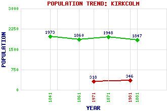
Kirkcolm (Stewarton) Classification and Statistics Settlement Type: village Population (1981): 346 (1971): 318 (1881): 1847 (1871): 1948 (1861): 1860 (1841): 1973 Tourist Rating: N/A Text of Entry Updated: 09-JAN-2007 Location Latitude: 54.9738°N Longitude: 5.0795°W National Grid Reference: NX 030 687 A range of modern and historical maps are accessible through the map tab on the right of this page Get directions by entering the UK postcode of your location, home or hotel here eg. EH1 3YT Use the tabs on the right of this page to see other parts of this entry Related Entries There are 19 related entries. (2 Attractions, 1 Council Area, 1 Historical County, 11 Features, 1 Parish, 1 Person and 2 Settlements) Names that are not linked do not currently contain any information. Attractions: Corsewall Castle Kilmorie Cross Council Area: Dumfries and Galloway Features: Blair More Hill Brown Hill Cairn Connell Hill Connell, Loch Ervie Hill Jamiesons Point Knockeen Rhins of Galloway, The Ryan, Loch Well Isle Wig, The Historical Counties: Wigtownshire Parishes: Kirkcolm People: Saint Columba(St. Columba or Saint Colum Cille) Settlements: Ervie Stranraer
There are 19 related entries. (2 Attractions, 1 Council Area, 1 Historical County, 11 Features, 1 Parish, 1 Person and 2 Settlements)
Names that are not linked do not currently contain any information.
By using our site you agree to accept cookies, which help us serve you better