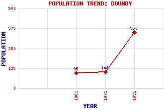
Dounby Classification and Statistics Settlement Type: village Population (1991): 350 (1971): 103 (1961): 95 Tourist Rating: No Text of Entry Updated: 19-SEP-2003 Location Latitude: 59.0674°N Longitude: 3.2312°W National Grid Reference: HY 295 207 A range of modern and historical maps are accessible through the map tab on the right of this page Get directions by entering the UK postcode of your location, home or hotel here eg. EH1 3YT Use the tabs on the right of this page to see other parts of this entry Related Entries There are 20 related entries. (2 Attractions, 1 Council Area, 1 Historical County, 9 Features, 1 Parish, 1 Person and 5 Settlements) Names that are not linked do not currently contain any information. Attractions: Kitchener Memorial Skara Brae Council Area: Orkney Features: Aiker Ness Boardhouse, Loch of Harray, Loch of Hundland, Loch of Milldoe Orkney Mainland Skaill House Skaill, Bay of Skaill, Loch of Historical Counties: Orkney Parishes: Sandwick People: Eric Robert Linklater Settlements: Kirkwall Quoyloo Skaill Skeabrae Twatt
There are 20 related entries. (2 Attractions, 1 Council Area, 1 Historical County, 9 Features, 1 Parish, 1 Person and 5 Settlements)
Names that are not linked do not currently contain any information.
By using our site you agree to accept cookies, which help us serve you better