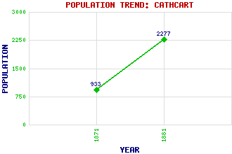
Cathcart Classification and Statistics Settlement Type: suburb Population (1881): 2277 (Old and New Cathcart combined) (1871): 933(New Cathcart) Tourist Rating: No Text of Entry Updated: 09-NOV-2009 Location Latitude: 55.8195°N Longitude: 4.2663°W National Grid Reference: NS 581 608 A range of modern and historical maps are accessible through the map tab on the right of this page Get directions by entering the UK postcode of your location, home or hotel here eg. EH1 3YT References and Further Reading Smart, Aileen (1996) Villages of Glasgow: Volume 2 (South of the Clyde). John Donald Publishers Ltd., Edinburgh Use the tabs on the right of this page to see other parts of this entry Related Entries There are 18 related entries. (2 Attractions, 1 Council Area, 1 Historical County, 1 Family, 4 Features, 1 Parish, 6 People and 2 Settlements) Names that are not linked do not currently contain any information. Attractions: Cathcart Castle King's Park Council Area: Glasgow City Families: Cathcart Features: Cathcart Old Bridge Cathcart Railway Station Newlands White Cart Water Historical Counties: Renfrewshire Parishes: Cathcart People: William Carstares Erik Chisholm Michael (Mike) Watson(Lord Watson of Invergowrie) James George Weir William Wilson Eric Woolfson Settlements: Glasgow Neilston
There are 18 related entries. (2 Attractions, 1 Council Area, 1 Historical County, 1 Family, 4 Features, 1 Parish, 6 People and 2 Settlements)
Names that are not linked do not currently contain any information.
By using our site you agree to accept cookies, which help us serve you better