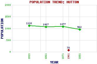
Hutton Classification and Statistics Settlement Type: village Population (1961): 78 (1881): 962 (1871): 1077 (1861): 1067 (1821): 1118 Tourist Rating: No Text of Entry Updated: 17-JAN-2007 Location Latitude: 55.7765°N Longitude: 2.1482°W National Grid Reference: NT 908 537 A range of modern and historical maps are accessible through the map tab on the right of this page Get directions by entering the UK postcode of your location, home or hotel here eg. EH1 3YT Use the tabs on the right of this page to see other parts of this entry Related Entries There are 14 related entries. (1 Attraction, 1 Council Area, 1 Historical County, 3 Features, 1 Parish, 2 People and 5 Settlements) Names that are not linked do not currently contain any information. Attractions: Wojtek the Bear Memorial Council Area: Scottish Borders Features: Hutton Castle Tweed, River Whiteadder Water Historical Counties: Berwickshire Parishes: Hutton People: Sir William Burrell David Milne-Home Settlements: Allanton Berwick-upon-Tweed Chirnside Chirnsidebridge Paxton
There are 14 related entries. (1 Attraction, 1 Council Area, 1 Historical County, 3 Features, 1 Parish, 2 People and 5 Settlements)
Names that are not linked do not currently contain any information.
By using our site you agree to accept cookies, which help us serve you better