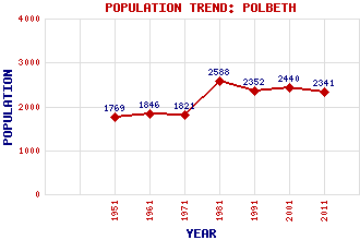
Polbeth Classification and Statistics Settlement Type: village Population (2011): 2341 (2001): 2440 (1991): 2352 (1981): 2588 (1971): 1821 (1961): 1846 (1951): 1769 Tourist Rating: N/A Text of Entry Updated: 06-SEP-2007 Location Latitude: 55.8593°N Longitude: 3.5544°W National Grid Reference: NT 028 640 A range of modern and historical maps are accessible through the map tab on the right of this page Get directions by entering the UK postcode of your location, home or hotel here eg. EH1 3YT Use the tabs on the right of this page to see other parts of this entry Related Entries There are 15 related entries. (1 Attraction, 1 Council Area, 1 Historical County, 8 Features, 1 Parish, 0 People and 3 Settlements) Names that are not linked do not currently contain any information. Attractions: Five Sisters Zoo Council Area: West Lothian Features: Breich Water Brotherton Harwood Water Hermand House Killandean Burn Limefield House West Calder Burn West Calder High School Historical Counties: Midlothian Parishes: West Calder Settlements: Bellsquarry Livingston West Calder
There are 15 related entries. (1 Attraction, 1 Council Area, 1 Historical County, 8 Features, 1 Parish, 0 People and 3 Settlements)
Names that are not linked do not currently contain any information.
By using our site you agree to accept cookies, which help us serve you better