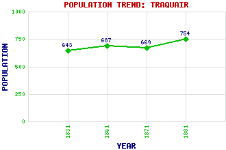
Traquair Classification and Statistics Settlement Type: village Population (1881): 754 (1871): 669 (1861): 687 (1831): 643 Tourist Rating: Yes Text of Entry Updated: 16-JUL-2009 Location Latitude: 55.6004°N Longitude: 3.0632°W National Grid Reference: NT 331 346 A range of modern and historical maps are accessible through the map tab on the right of this page Get directions by entering the UK postcode of your location, home or hotel here eg. EH1 3YT Use the tabs on the right of this page to see other parts of this entry Related Entries There are 15 related entries. (4 Attractions, 1 Council Area, 1 Historical County, 1 Family, 3 Features, 1 Parish, 2 People and 2 Settlements) Names that are not linked do not currently contain any information. Attractions: Sir Walter Scott Way Southern Upland Way Traquair House Traquair Kirk Council Area: Scottish Borders Families: Stewart Features: Fingland Burn Glen House Quair Water Historical Counties: Peeblesshire Parishes: Traquair People: James Dickson Prof. James Nicol Settlements: Innerleithen Yarrow
There are 15 related entries. (4 Attractions, 1 Council Area, 1 Historical County, 1 Family, 3 Features, 1 Parish, 2 People and 2 Settlements)
Names that are not linked do not currently contain any information.
By using our site you agree to accept cookies, which help us serve you better