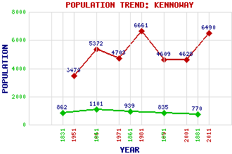
Kennoway Classification and Statistics Settlement Type: village Population (2011): 6490 (Combined with Windygates) (2001): 4628 (1991): 4609 (1981): 6661(Combined with Windygates) (1971): 4703 (1961): 5372 (1951): 3479 (1881): 770 (1871): 835 (1861): 939 (1841): 1101 (1831): 862 Tourist Rating: No Text of Entry Updated: 04-JUN-2006 Location Latitude: 56.2088°N Longitude: 3.0429°W National Grid Reference: NO 354 023 A range of modern and historical maps are accessible through the map tab on the right of this page Get directions by entering the UK postcode of your location, home or hotel here eg. EH1 3YT Use the tabs on the right of this page to see other parts of this entry Related Entries There are 23 related entries. (1 Attraction, 1 Council Area, 1 Historical County, 1 Event, 5 Features, 1 Parish, 2 People and 11 Settlements) Names that are not linked do not currently contain any information. Attractions: Praytis Country Park Council Area: Fife Events: Reformation, The Features: Clatto Hill Donald Rose Reservoir Forth, Firth of Langside Hill Tay, Firth of Historical Counties: Fife Parishes: Kennoway People: Thomas Hamilton John Row Settlements: Baintown Bonnybank Clatto Langdyke Leven Montrave Pettycur Pratis Struthers Tayport Windygates
There are 23 related entries. (1 Attraction, 1 Council Area, 1 Historical County, 1 Event, 5 Features, 1 Parish, 2 People and 11 Settlements)
Names that are not linked do not currently contain any information.
By using our site you agree to accept cookies, which help us serve you better