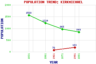
Kirkmichael Classification and Statistics Settlement Type: village Population (1991): 183 (1961): 76 (1881): 849 (1871): 965 (1861): 1224 (1831): 1568 Tourist Rating: No Text of Entry Updated: 04-NOV-2015 Location Latitude: 56.7234°N Longitude: 3.5049°W National Grid Reference: NO 080 601 A range of modern and historical maps are accessible through the map tab on the right of this page Get directions by entering the UK postcode of your location, home or hotel here eg. EH1 3YT Use the tabs on the right of this page to see other parts of this entry Related Entries There are 23 related entries. (1 Attraction, 1 Council Area, 1 Historical County, 1 Event, 8 Features, 1 Parish, 0 People and 10 Settlements) Names that are not linked do not currently contain any information. Attractions: Cateran Trail, The Council Area: Perth and Kinross Events: 1715 Jacobite Rebellion Features: Ardle, Strath Balnald Burn Balvarran Curran, Loch Derby, Glen Kindrogan Field Centre Shee Water Tullochcurran Burn Historical Counties: Perthshire Parishes: Kirkmichael Settlements: Ballinluig Ballintuim Balmyle Balnald Enochdhu Glenderby Moulin Pitcarmick Pitlochry Stylemouth
There are 23 related entries. (1 Attraction, 1 Council Area, 1 Historical County, 1 Event, 8 Features, 1 Parish, 0 People and 10 Settlements)
Names that are not linked do not currently contain any information.
By using our site you agree to accept cookies, which help us serve you better