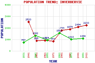
Inverbervie Classification and Statistics Settlement Type: village Population (2011): 2233 (2001): 2094 (1991): 1879 (1981): 1799(Combined with Gourdon) (1971): 850 (1961): 921 (1951): 885 (1901): 2523(Royal Burgh) (1881): 1094 (1871): 1013 (1861): 1561 (1851): 934 (1841): 1342 (1831): 757 Tourist Rating: Text of Entry Updated: 12-JUN-2007 Location Latitude: 56.8445°N Longitude: 2.2803°W National Grid Reference: NO 830 726 A range of modern and historical maps are accessible through the map tab on the right of this page Get directions by entering the UK postcode of your location, home or hotel here eg. EH1 3YT Use the tabs on the right of this page to see other parts of this entry Related Entries There are 27 related entries. (2 Attractions, 1 Council Area, 1 Historical County, 2 Families, 6 Features, 1 Parish, 5 People and 9 Settlements) Names that are not linked do not currently contain any information. Attractions: Hallgreen Castle North Water Viaduct Council Area: Aberdeenshire Families: Dunnet Rait Features: Bervie Bay Bervie Brow Bervie Water Knox Hill North Sea Todhead Point Historical Counties: Kincardineshire Parishes: Bervie People: John Arbuthnot Sir Francis Chichester King David II Kirsty Hume Hercules Linton Settlements: Arbuthnott Benholm Catterline Gourdon Kinneff Knox Laurencekirk Montrose Roadside of Kinneff
There are 27 related entries. (2 Attractions, 1 Council Area, 1 Historical County, 2 Families, 6 Features, 1 Parish, 5 People and 9 Settlements)
Names that are not linked do not currently contain any information.
By using our site you agree to accept cookies, which help us serve you better