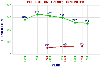
Innerwick Classification and Statistics Settlement Type: village Population (1991): 200 (1971): 195 (1961): 155 (1891): 761(For parish) (1881): 777(For parish) (1871): 892(For parish) (1861): 937(For parish) (1831): 987(For parish) (1801): 846(For parish) Tourist Rating: N/A Text of Entry Updated: 06-MAY-2019 Location Latitude: 55.9582°N Longitude: 2.4484°W National Grid Reference: NT 721 739 A range of modern and historical maps are accessible through the map tab on the right of this page Get directions by entering the UK postcode of your location, home or hotel here eg. EH1 3YT Use the tabs on the right of this page to see other parts of this entry Related Entries There are 20 related entries. (1 Attraction, 1 Council Area, 1 Historical County, 1 Event, 2 Families, 8 Features, 1 Parish, 1 Person and 4 Settlements) Names that are not linked do not currently contain any information. Attractions: Torness Nuclear Power Station Council Area: East Lothian Events: Rough Wooing, The Families: Hamilton Stewart Features: Blackcastle Hill East Coast Main Line East Lammermuir Deans Nature Reserve Falsely Hill Fenton Tower Innerwick Castle North Sea Thornton Burn Historical Counties: East Lothian Parishes: Innerwick People: Edward Seymour(Earl of Hertford; 1st Duke of Somerset) Settlements: Crowhill Dunbar Skateraw Thornton
There are 20 related entries. (1 Attraction, 1 Council Area, 1 Historical County, 1 Event, 2 Families, 8 Features, 1 Parish, 1 Person and 4 Settlements)
Names that are not linked do not currently contain any information.
By using our site you agree to accept cookies, which help us serve you better