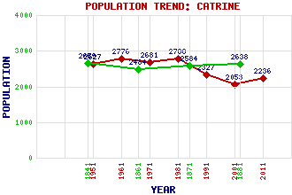
Catrine Classification and Statistics Settlement Type: village Population (2011): 2236 (2001): 2053 (1991): 2327 (1981): 2788 (1971): 2681 (1961): 2776 (1951): 2627 (1881): 2638 (1871): 2584 (1861): 2484 (1841): 2659 Tourist Rating: N/A Text of Entry Updated: 19-SEP-2003 Location Latitude: 55.5009°N Longitude: 4.3367°W National Grid Reference: NS 525 255 A range of modern and historical maps are accessible through the map tab on the right of this page Get directions by entering the UK postcode of your location, home or hotel here eg. EH1 3YT Use the tabs on the right of this page to see other parts of this entry Related Entries There are 16 related entries. (2 Attractions, 1 Council Area, 1 Historical County, 6 Features, 1 Parish, 3 People and 2 Settlements) Names that are not linked do not currently contain any information. Attractions: Ballochmyle Viaduct Howford Bridge Council Area: East Ayrshire Features: Ayr, River Ballochmyle Bridge Ballochmyle House Daldorch House Glenbuck Loch River Ayr Way Historical Counties: Ayrshire Parishes: Sorn People: David Dale (James) Stuart Park Matthew Stewart Settlements: Ballochmyle Mauchline
There are 16 related entries. (2 Attractions, 1 Council Area, 1 Historical County, 6 Features, 1 Parish, 3 People and 2 Settlements)
Names that are not linked do not currently contain any information.
By using our site you agree to accept cookies, which help us serve you better