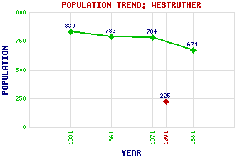
Westruther Classification and Statistics Settlement Type: village Population (1991): 225 (1881): 671 (1871): 784 (1861): 786 (1831): 830 Tourist Rating: N/A Text of Entry Updated: 19-APR-2011 Location Latitude: 55.7419°N Longitude: 2.5861°W National Grid Reference: NT 633 500 A range of modern and historical maps are accessible through the map tab on the right of this page Get directions by entering the UK postcode of your location, home or hotel here eg. EH1 3YT Use the tabs on the right of this page to see other parts of this entry Related Entries There are 10 related entries. (0 Attractions, 1 Council Area, 1 Historical County, 3 Features, 1 Parish, 1 Person and 3 Settlements) Names that are not linked do not currently contain any information. Council Area: Scottish Borders Features: Blackadder Water Lammermuir Hills Scoured Rig Historical Counties: Berwickshire Parishes: Westruther People: Lady Alicia Scott(Alicia Spottiswoode) Settlements: Greenlaw Lauder Longformacus
There are 10 related entries. (0 Attractions, 1 Council Area, 1 Historical County, 3 Features, 1 Parish, 1 Person and 3 Settlements)
Names that are not linked do not currently contain any information.
By using our site you agree to accept cookies, which help us serve you better