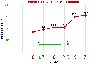
Howwood Classification and Statistics Settlement Type: village Population (2011): 1558 (2001): 1502 (1991): 1036 (1981): 1038 (1971): 960 (1961): 847 (1881): 333 (1871): 312 Tourist Rating: No Text of Entry Updated: 20-FEB-2014 Location Latitude: 55.8102°N Longitude: 4.5579°W National Grid Reference: NS 398 604 A range of modern and historical maps are accessible through the map tab on the right of this page Get directions by entering the UK postcode of your location, home or hotel here eg. EH1 3YT Use the tabs on the right of this page to see other parts of this entry Related Entries There are 18 related entries. (0 Attractions, 1 Council Area, 1 Historical County, 12 Features, 1 Parish, 0 People and 3 Settlements) Names that are not linked do not currently contain any information. Council Area: Renfrewshire Features: Ayrshire Coast Line Barcraigs Reservoir Bowfield Dam Broadfield Hill Castle Semple Gleniffer Braes Howwood Railway Station Kenmure Hill Rowbank Reservoir Temple, The Walls Hill Walls Loch Historical Counties: Renfrewshire Parishes: Lochwinnoch Settlements: Johnstone Kilbarchan Paisley
There are 18 related entries. (0 Attractions, 1 Council Area, 1 Historical County, 12 Features, 1 Parish, 0 People and 3 Settlements)
Names that are not linked do not currently contain any information.
By using our site you agree to accept cookies, which help us serve you better