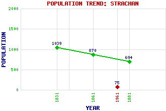
Strachan Classification and Statistics Settlement Type: village Population (1961): 75 (1881): 694 (1861): 870 (1831): 1039 Tourist Rating: N/A Text of Entry Updated: 06-SEP-2007 Location Latitude: 57.0206°N Longitude: 2.5402°W National Grid Reference: NO 673 923 A range of modern and historical maps are accessible through the map tab on the right of this page Get directions by entering the UK postcode of your location, home or hotel here eg. EH1 3YT Use the tabs on the right of this page to see other parts of this entry Related Entries There are 17 related entries. (1 Attraction, 1 Council Area, 1 Historical County, 10 Features, 1 Parish, 0 People and 3 Settlements) Names that are not linked do not currently contain any information. Attractions: Deeside Council Area: Aberdeenshire Features: Cairn o' Mount Clachnaben Craig of Dalfro Dye, Glen Dye, Water of Feugh, Water of Glendye Lodge Goauch, Hill of Mount Shade Scolty Historical Counties: Kincardineshire Parishes: Strachan Settlements: Banchory Belts of Collonach Fettercairn
There are 17 related entries. (1 Attraction, 1 Council Area, 1 Historical County, 10 Features, 1 Parish, 0 People and 3 Settlements)
Names that are not linked do not currently contain any information.
By using our site you agree to accept cookies, which help us serve you better