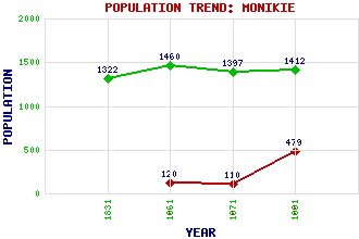
Monikie Classification and Statistics Settlement Type: village Population (1991): 479 (1971): 110 (1961): 120 (1881): 1412 (1871): 1397 (1861): 1460 (1831): 1322 Tourist Rating: Text of Entry Updated: 15-AUG-2004 Location Latitude: 56.5367°N Longitude: 2.8145°W National Grid Reference: NO 500 386 A range of modern and historical maps are accessible through the map tab on the right of this page Get directions by entering the UK postcode of your location, home or hotel here eg. EH1 3YT Use the tabs on the right of this page to see other parts of this entry Related Entries There are 20 related entries. (1 Attraction, 1 Council Area, 1 Historical County, 3 Families, 6 Features, 1 Parish, 1 Person and 6 Settlements) Names that are not linked do not currently contain any information. Attractions: Monikie Country Park Council Area: Angus Families: Auchileck Lindsay Panmure Features: Affleck Castle Carrot Hill Hare Cairn Hatton Cairn Panmure Panmure Testimonial Historical Counties: Angus Parishes: Monikie People: James Scott Skinner Settlements: Craigton Dundee Kirkton of Monikie Monifieth Newbigging Wellbank
There are 20 related entries. (1 Attraction, 1 Council Area, 1 Historical County, 3 Families, 6 Features, 1 Parish, 1 Person and 6 Settlements)
Names that are not linked do not currently contain any information.
By using our site you agree to accept cookies, which help us serve you better