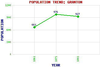
Granton Classification and Statistics Settlement Type: suburb Population (1881): 927 (1871): 976 (1861): 661 Tourist Rating: No Text of Entry Updated: 31-JUL-2023 Location Latitude: 55.9805°N Longitude: 3.2283°W National Grid Reference: NT 234 770 A range of modern and historical maps are accessible through the map tab on the right of this page Get directions by entering the UK postcode of your location, home or hotel here eg. EH1 3YT Use the tabs on the right of this page to see other parts of this entry Related Entries There are 55 related entries. (1 Attraction, 1 Council Area, 1 Historical County, 2 Families, 30 Features, 1 Parish, 13 People and 6 Settlements) Names that are not linked do not currently contain any information. Attractions: King George V Park Council Area: City of Edinburgh Families: Buccleuch Melville Features: Birnie Rocks Burntisland Railway Station Caroline Park Craigleith Drum Sands East Pilton Edinburgh College Forth, Firth of Forthquarter Forthquarter Park Granton Gas Works Granton Harbour Granton Lighthouse Granton Waterfront Inchkeith Inchmickery Madelvic House and Works National Museums Collection Centre North Sea Northern Lighthouse Board Operational Base Royston Scottish Association for Marine Science, St Margaret's Head Tunnel Tay Bridge Trinity Wardie Wardieburn Waverley Railway Station West Pilton Whinnyknowe Historical Counties: Midlothian Parishes: Edinburgh People: Sir Thomas Bouch George Cleghorn Adam Gifford(Lord Gifford) Thomas Grainger Charles Hope(Lord Granton) Walter Francis Montagu Douglas Scott(5th Duke of Buccleuch; 7th Duke of Queensberry) Sir John Murray Robert Napier Sir William Peck Sir Walter Scott Edward Seymour(Earl of Hertford; 1st Duke of Somerset) Robert Stevenson James Walker Settlements: Burntisland D'Arcy Dunstaffnage Edinburgh Millport Newhaven
There are 55 related entries. (1 Attraction, 1 Council Area, 1 Historical County, 2 Families, 30 Features, 1 Parish, 13 People and 6 Settlements)
Names that are not linked do not currently contain any information.
By using our site you agree to accept cookies, which help us serve you better