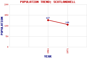
Scotlandwell (Fons Scotia) Classification and Statistics Settlement Type: village Population (1971): 106 (1961): 127 Tourist Rating: N/A Text of Entry Updated: 13-OCT-2007 Location Latitude: 56.2°N Longitude: 3.3151°W National Grid Reference: NO 185 016 A range of modern and historical maps are accessible through the map tab on the right of this page Get directions by entering the UK postcode of your location, home or hotel here eg. EH1 3YT Use the tabs on the right of this page to see other parts of this entry Related Entries There are 13 related entries. (1 Attraction, 1 Council Area, 1 Historical County, 3 Features, 1 Parish, 2 People and 4 Settlements) Names that are not linked do not currently contain any information. Attractions: Portmoak Airfield Council Area: Perth and Kinross Features: Arnot Reservoir Bishop Hill Leven, Loch Historical Counties: Kinross-shire Parishes: Portmoak People: David Bryce King Robert I(Robert the Bruce) Settlements: Arnot Kinnesswood Leslie Portmoak
There are 13 related entries. (1 Attraction, 1 Council Area, 1 Historical County, 3 Features, 1 Parish, 2 People and 4 Settlements)
Names that are not linked do not currently contain any information.
By using our site you agree to accept cookies, which help us serve you better