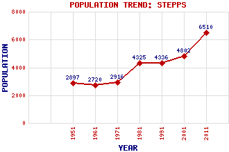
Stepps Classification and Statistics Settlement Type: suburb Population (2011): 6510 (2001): 4802 (1991): 4336 (1981): 4325 (1971): 2916 (1961): 2720 (1951): 2897 Tourist Rating: N/A Text of Entry Updated: 31-JAN-2024 Location Latitude: 55.8909°N Longitude: 4.1442°W National Grid Reference: NS 660 685 A range of modern and historical maps are accessible through the map tab on the right of this page Get directions by entering the UK postcode of your location, home or hotel here eg. EH1 3YT Use the tabs on the right of this page to see other parts of this entry Related Entries There are 14 related entries. (1 Attraction, 1 Council Area, 1 Historical County, 5 Features, 1 Parish, 0 People and 5 Settlements) Names that are not linked do not currently contain any information. Attractions: Summerlee Museum of Scottish Industrial Life Council Area: North Lanarkshire Features: Corbiewood Stadium Craigend Frankfield Loch Our Lady's High School Stepps Railway Station Historical Counties: Lanarkshire Parishes: Cadder Settlements: Cardowan Garthamlock Glasgow Millerston Robroyston
There are 14 related entries. (1 Attraction, 1 Council Area, 1 Historical County, 5 Features, 1 Parish, 0 People and 5 Settlements)
Names that are not linked do not currently contain any information.
By using our site you agree to accept cookies, which help us serve you better