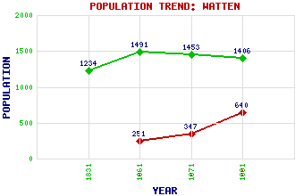
Watten Classification and Statistics Settlement Type: village Population (1991): 640 (1971): 347 (1961): 251 (1881): 1406 (1871): 1453 (1861): 1491 (1831): 1234 Tourist Rating: No Text of Entry Updated: 03-JAN-2008 Location Latitude: 58.4703°N Longitude: 3.3046°W National Grid Reference: ND 240 543 A range of modern and historical maps are accessible through the map tab on the right of this page Get directions by entering the UK postcode of your location, home or hotel here eg. EH1 3YT References and Further Reading Campbell, Valerie (2007) Camp 165 Watten: Scotland's Most Secretive POW Camp. Whittles Publishing, Dunbeath Use the tabs on the right of this page to see other parts of this entry Related Entries There are 17 related entries. (0 Attractions, 1 Council Area, 1 Historical County, 7 Features, 1 Parish, 2 People and 5 Settlements) Names that are not linked do not currently contain any information. Council Area: Highland Features: Acharole, Burn of Backlass Hill Bilbster Wind Farm Caithness Toftingall, Loch of Watten Station Watten, Loch Historical Counties: Caithness Parishes: Watten People: Alexander Bain Richard Oswald Settlements: Backlass Badlipster Mybster Thurso Wick
There are 17 related entries. (0 Attractions, 1 Council Area, 1 Historical County, 7 Features, 1 Parish, 2 People and 5 Settlements)
Names that are not linked do not currently contain any information.
By using our site you agree to accept cookies, which help us serve you better