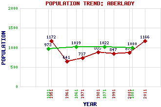
Aberlady Classification and Statistics Settlement Type: village Population (2011): 1166 (2001): 873 (1991): 847 (1981): 885(Combined with Craigielaw) (1971): 737 (1961): 641 (1951): 1172 (1881): 1000 (1871): 1022 (1861): 1019 (1831): 973 Tourist Rating: Text of Entry Updated: 07-NOV-2011 Location Latitude: 56.009°N Longitude: 2.8579°W National Grid Reference: NT 466 799 A range of modern and historical maps are accessible through the map tab on the right of this page Get directions by entering the UK postcode of your location, home or hotel here eg. EH1 3YT Use the tabs on the right of this page to see other parts of this entry Related Entries There are 35 related entries. (8 Attractions, 1 Council Area, 1 Historical County, 10 Features, 1 Parish, 4 People and 10 Settlements) Names that are not linked do not currently contain any information. Attractions: Aberlady Bay Local Nature Reserve Aberlady Parish Church Ballencrieff Castle Hopetoun Monument John Muir Way Murrayfield Ice Rink Myreton Motor Museum Waterston House Council Area: East Lothian Features: Aberlady Bay Aberlady Golf Club Aberlady Point Craigielaw Point Forth, Firth of Gosford Bay Gosford House Luffness Convent Luffness House Redhouse Castle Historical Counties: East Lothian Parishes: Aberlady People: Rev. John Gray John Campbell Mitchell General James Murray Nigel Tranter(Nye Tredgold) Settlements: Abercorn Ballencrieff Craigielaw Drem Gullane Haddington Kilspindie Longniddry Luffness Spittal
There are 35 related entries. (8 Attractions, 1 Council Area, 1 Historical County, 10 Features, 1 Parish, 4 People and 10 Settlements)
Names that are not linked do not currently contain any information.
By using our site you agree to accept cookies, which help us serve you better