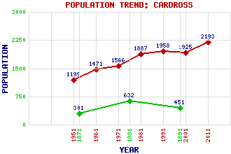
Cardross Classification and Statistics Settlement Type: village Population (2011): 2193 (2001): 1925 (1991): 1958 (1981): 1887 (1971): 1566 (1961): 1471 (1951): 1199 (1891): 451 (1881): 632 (1871): 301 Tourist Rating: N/A Text of Entry Updated: 04-JUL-2009 Location Latitude: 55.961°N Longitude: 4.6528°W National Grid Reference: NS 345 774 A range of modern and historical maps are accessible through the map tab on the right of this page Get directions by entering the UK postcode of your location, home or hotel here eg. EH1 3YT Use the tabs on the right of this page to see other parts of this entry Related Entries There are 29 related entries. (6 Attractions, 1 Council Area, 1 Historical County, 8 Features, 1 Parish, 6 People and 6 Settlements) Names that are not linked do not currently contain any information. Attractions: Cardross Castle Geilston Gardens Inner Clyde Nature Reserve Kirkton Chapel Levengrove Park St Mahew's Chapel Council Area: Argyll and Bute Features: Ardmore Cardross Crematorium Cardross Railway Station Carman Reservoir Clyde, Firth of Kilmahew Castle Kilmahew House St Peter's Seminary Historical Counties: Dunbartonshire Parishes: Cardross People: James Burns Archibald Joseph Cronin(A.J. Cronin) William (Willie) Fernie Percy Sinclair Pilcher King Robert I(Robert the Bruce) Tobias George Smollett Settlements: Ardmore Colgrain Dumbarton Helensburgh Kilmahew Kirkton
There are 29 related entries. (6 Attractions, 1 Council Area, 1 Historical County, 8 Features, 1 Parish, 6 People and 6 Settlements)
Names that are not linked do not currently contain any information.
By using our site you agree to accept cookies, which help us serve you better