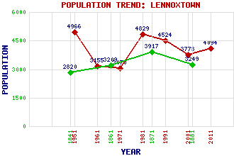
Lennoxtown (Newton of Campsie) Classification and Statistics Settlement Type: village Population (2011): 4094 (2001): 3773 (1991): 4524 (1981): 4829 (1971): 3070 (1961): 3155 (1951): 4966 (1881): 3249 (1871): 3917 (1861): 3209 (1841): 2820 Tourist Rating: Text of Entry Updated: 10-JAN-2007 Location Latitude: 55.9735°N Longitude: 4.2016°W National Grid Reference: NS 627 778 A range of modern and historical maps are accessible through the map tab on the right of this page Get directions by entering the UK postcode of your location, home or hotel here eg. EH1 3YT Use the tabs on the right of this page to see other parts of this entry Related Entries There are 22 related entries. (2 Attractions, 1 Council Area, 1 Historical County, 11 Features, 1 Parish, 3 People and 3 Settlements) Names that are not linked do not currently contain any information. Attractions: John Muir Way Thomas Muir Heritage Trail Council Area: East Dunbartonshire Features: Campsie Golf Club Crow Road, The Finglen Burn Glazert Water Hart Hill Kilsyth Hills Lecket Hill Lennox Lennox Castle Lennoxtown Training Ground Meikle Bin Historical Counties: Stirlingshire Parishes: Campsie People: Robert Dalglish Owen (Onnie) McIntyre Sir Thomas Livingstone Mitchell Settlements: Campsie Fintry Haughhead
There are 22 related entries. (2 Attractions, 1 Council Area, 1 Historical County, 11 Features, 1 Parish, 3 People and 3 Settlements)
Names that are not linked do not currently contain any information.
By using our site you agree to accept cookies, which help us serve you better