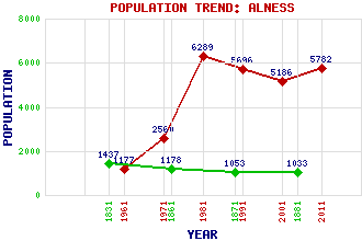
Alness Classification and Statistics Settlement Type: small town Population (2011): 5782 (2001): 5186 (1991): 5696 (1981): 6289 (1971): 2560 (1961): 1177 (1881): 1033 (1871): 1053 (1861): 1178 (1831): 1437 Tourist Rating: No Text of Entry Updated: 23-JUL-2019 Location Latitude: 57.6959°N Longitude: 4.2615°W National Grid Reference: NH 653 696 A range of modern and historical maps are accessible through the map tab on the right of this page Get directions by entering the UK postcode of your location, home or hotel here eg. EH1 3YT Use the tabs on the right of this page to see other parts of this entry Related Entries There are 40 related entries. (1 Attraction, 1 Council Area, 1 Historical County, 16 Features, 14 Parishes, 0 People and 7 Settlements) Names that are not linked do not currently contain any information. Attractions: Dalmore Distillery Council Area: Highland Features: A9 Trunk Road Achnacloich, Loch Alness Academy Alness Golf Club Alness Point Alness Railway Station Alness River Bad a' Bhathaich, Loch Beinn Tharsuinn Easter Ross Fyrish Hill Kildermorie Forest Morie, Loch North Highland College Struie White Hills Historical Counties: Ross and Cromarty Parishes: Alness Avoch Cromarty Dingwall Edderton Fearn Fodderty Kilmuir Easter Kiltearn Logie Easter Resolis Rosemarkie Rosskeen Tain Settlements: Achandunie Ardross Boath Dalmore Evanton Inchindown Nonikiln
There are 40 related entries. (1 Attraction, 1 Council Area, 1 Historical County, 16 Features, 14 Parishes, 0 People and 7 Settlements)
Names that are not linked do not currently contain any information.
By using our site you agree to accept cookies, which help us serve you better