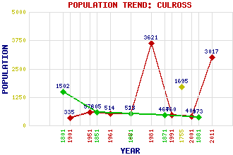
Culross Classification and Statistics Settlement Type: village Population (2011): 3017 (Combined with High Valleyfield) (2001): 404 (1991): 460 (1981): 3621(Combined with High Valleyfield) (1971): 523 (1961): 514 (1951): 578 (1901): 335(Parliamentary Burgh) (1881): 373 (1871): 467 (1861): 517 (1851): 605 (1801): 1502 (1755): 1695 Tourist Rating: Text of Entry Updated: 01-JUL-2023 Location Latitude: 56.0552°N Longitude: 3.6281°W National Grid Reference: NS 987 859 A range of modern and historical maps are accessible through the map tab on the right of this page Get directions by entering the UK postcode of your location, home or hotel here eg. EH1 3YT Use the tabs on the right of this page to see other parts of this entry Related Entries There are 50 related entries. (9 Attractions, 1 Council Area, 1 Historical County, 4 Families, 8 Features, 1 Parish, 16 People and 10 Settlements) Names that are not linked do not currently contain any information. Attractions: Bessie Bar's Hall Bishop Leighton's House Culross Abbey Culross Abbey Church Culross Mercat Cross Culross Palace Culross Town House Tron, The Valleyfield Woodland Park Council Area: Fife Families: Bruce MacDuff Preston Primrose Features: Blair Castle Bordie Castle Brankstone Grange Culross Abbey House Forth, Firth of Forth, River Moat, The Study, The Historical Counties: Fife Parishes: Culross People: Robert Bald Sir George Bruce Archibald Cochrane(9th Earl of Dundonald) Thomas Cochrane(10th Earl of Dundonald) Thomas Mackay Cooper(1st Baron Cooper of Culross) Bill Findlay King James IV King James VI(James I of England) Saint Kentigern(St. Kentigern or St. Mungo) Jessie Marion King Ian Gordon Lindsay Malcolm MacDuff(7th Earl of Fife) Dr. John Moultrie Sir Robert Preston Douglas (Dougie) Vipond George Younger Settlements: Bath Carnock Cromarty Crossford Dunfermline Dunning Low Valleyfield Shiresmill Torryburn Valleyfield
There are 50 related entries. (9 Attractions, 1 Council Area, 1 Historical County, 4 Families, 8 Features, 1 Parish, 16 People and 10 Settlements)
Names that are not linked do not currently contain any information.
By using our site you agree to accept cookies, which help us serve you better